 Handy GPS

A fully featured, great value hiking GPS for the real world. No signup required.
Read more
A fully featured, great value hiking GPS for the real world. No signup required.
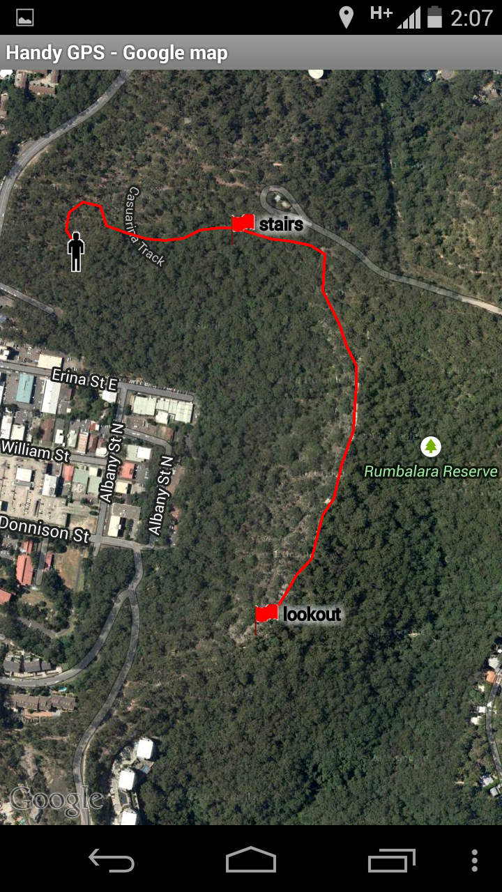
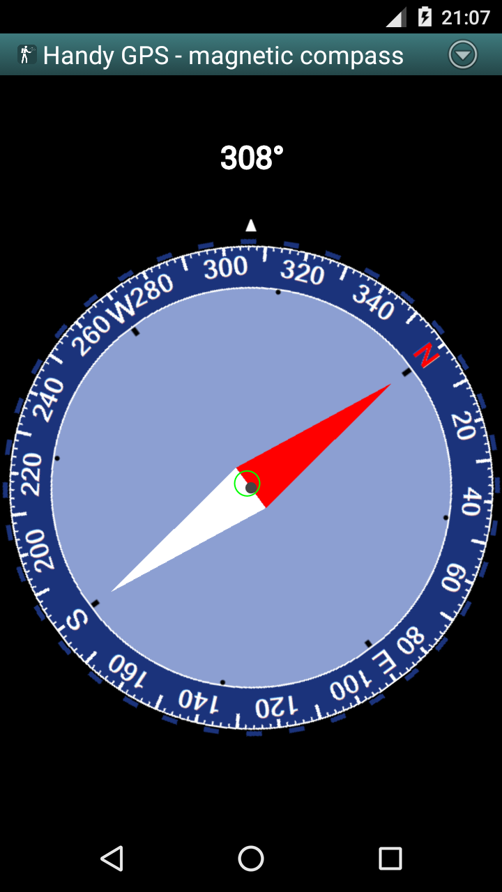
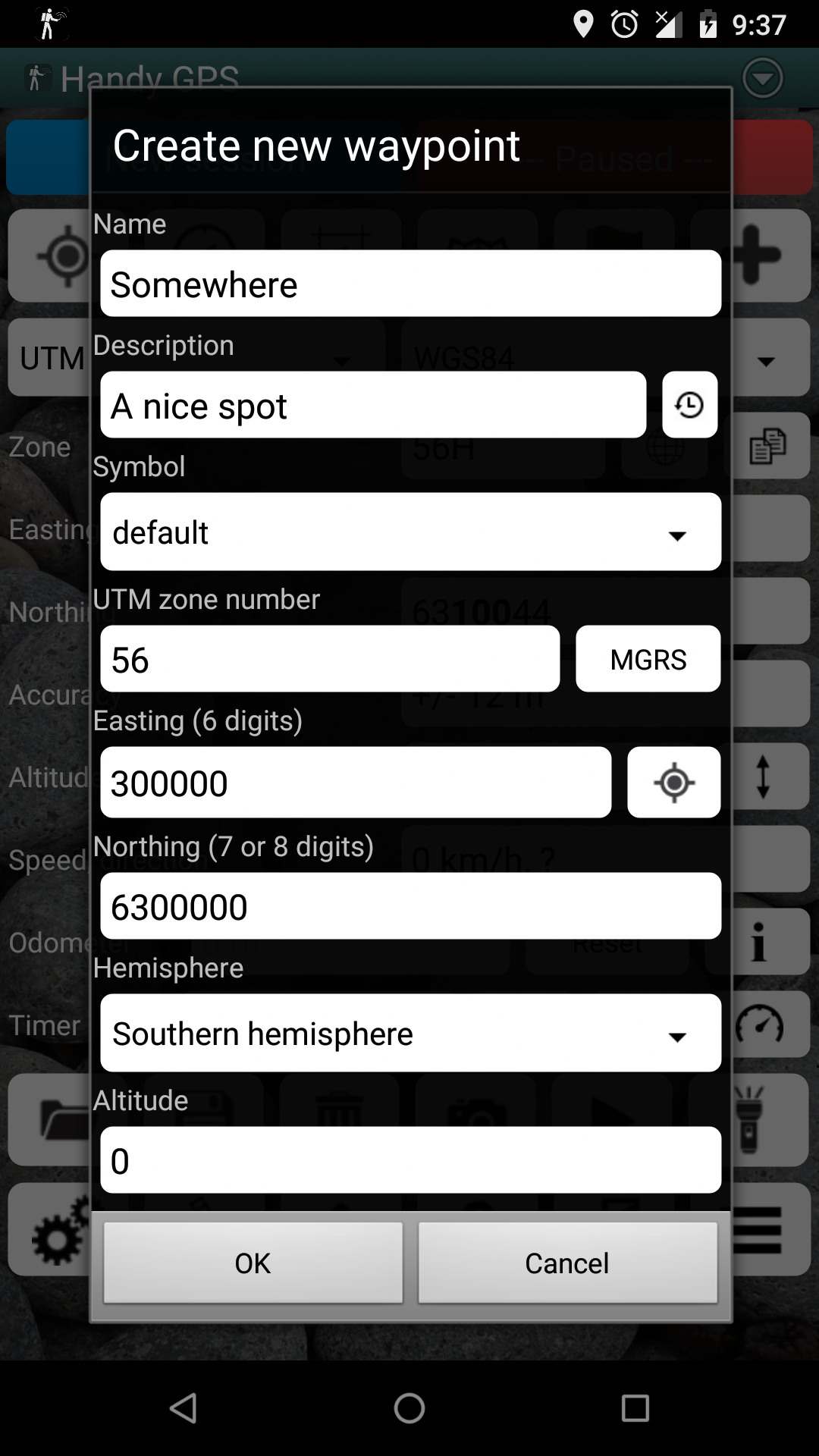
The perfect companion for your next outdoor adventure. Seek, find, record and return home with Handy GPS.This app is a powerful navigation tool designed for outdoors sports like hiking, bushwalking, tramping, mountain biking, kayaking, boating, horse trail riding, geocaching. Its also useful for surveying, mining, archaeology, and forestry applications. Its simple to use and works even in the remotest back country since it doesnt require network connectivity. It allows you to work in UTM or lat/lon coordinates so you can even use it with your paper maps.BASE FEATURES:* Shows your current coordinates, altitude, speed, direction of travel, and distance travelled in metric, imperial/US, or nautical units.* Can store your current location as a waypoint, and record a track log to show where youve been on a map.* Data can be imported from and exported to KML and GPX files.* Allows manual entry of waypoints in UTM, MGRS and lat/lon coords.* Can guide you to a waypoint using the "Goto" screen, and optionally sound an alert when when youre getting close.* Has a compass page which works on devices with magnetic field sensors.* Automatically computes the local geoid offset to improve altitude accuracy* Supports the world-wide WGS84 datum along with the common Australian datums and map grids (AGD66, AGD84, AMG, GDA94, and MGA). You can also use WGS84 for NAD83 maps in the US.* Shows GPS satellite locations and signal strengths graphically.* Can display simple or MGRS grid references.* Can compute waypoint-to-waypoint distance and direction.* Includes an optional timer line to record walk duration and compute your average speed.* Thoroughly tested by the developer on many off-track walksEXTRA FEATURES IN THIS VERSION:* No ads, no subscriptions, and nothing more to pay after your initial purchase.* Unlimited number of waypoints and track log points.* Email or SMS your location to a friend as a clickable map link.* Email your waypoints and tracklogs as KML or GPX file.* Supports common datums such as NAD83 (US), OSGB36 (UK), NZTM2000 (NZ), SAD69 (South America) and ED50 (Europe), and you can configure your own custom datums, including local grid systems.* UK grid refs with two letter prefixes can be shown if OSGB datum selected.* Elevation profile.* GPS averaging mode.* Take photos and record voice memos, geo-located with KML files for easy viewing on a PC.* Geo-tag photos, and/or have the coordinates and bearing "burnt" into the image.* Sun rise and set times.* Export data to CSV file.* Create waypoint by triangulation, or projecting using an entered distance and bearing.* Compute length, area, and elevation change for tracklog.* Offline map support by downloading tiles from map tile servers, or using own map images.* Compute calories.* Optional background image.* Optional location sharing on web.* Spoken distance and direction guidance on goto page.PERMISSIONS: (1) GPS, to show your location, (2) Network access, to load maps, (3) SD card access, to load and store waypoints, (4) Camera access, for taking pics, (5) Prevent phone from sleeping, so proximity alarm works, (6) Control flashlight, to allow flashlight use, (7) Record audio for voice memos.DISCLAIMER: You use this app at your own risk. The developer accepts no responsibility for you getting lost or injured as a result of using this app. Batteries in mobile devices can go flat. For extended and remote hikes, a battery bank and an alternative method of navigation such as a paper map and compass are recommended for safety.38.0: Fixed bug with exporting data to CSV and TXT files when there are tracklog points but no waypoints.37.9: Added 5km and 10km as tracklog spacing options.37.8: Only request audio permission when taking voice memos. Bug fixes.37.7: Added paste option when manually entering coordinates.37.6: Improved speed of offline maps. Sort files correctly in file browser. Long-press on compass page to show "held" bearing. Bug fixes.
Read trusted reviews from application customers
Takes getting used to...I don't think there is smart phone support for Garmin Fenix 3 as I checked the IQ connect store and it didn't have Handy GPS listed.
My app is still not yet installed. I'm hoping for the installation to be done to experience it's working.
Exellent Handy Gps
I've been using this for years for backcountry navigation with compass backup, haven't run across something better, though I browse occasionally. Straightforward gps app, easy navigation and easy to export data. Defaults to satellite imagery which is fine. Load the maps while you have a signal though, if you're using it backcountry.
A professionally detailed GPS app. It has everything required for a safe trek home. The video is well presented and email support by Anthony Dunk absolutely brilliant ... Would I recommend this app? A resounding definite and absolute YES👍
Always been accurate. Great for displaying impressive results of a day out hiking when overlaid with a satellite image.
2 requests: need permanent Waypoints. They disappear with each new session, and it would be good if things like "HOME" always carried over. Also, more features on the nav screen would help. Like TTM and VMG. Updating review, 2 star less. Updates are causing problems. When I go to a different screen, there is no longer a button to get back to main screen. I have to quit and restart. The app now also stops tracking as soon as the phone screen goes to sleep. I need to hike with the screen on
This is a great app that I use regularly. Support is excellent. I reported a problem I encountered with v37.4 and an update with a fix was posted in hours.
Just updating my original review of the Handy GPS app from 2012. I've been using the paid version of this app for 9 years now, and it's still perfect. Developer has added some very nice features to it over the years and has done a great job maintaining it! No need to look at any other apps for backcountry activities. Altimeter and location coordinates are always accurate, and it doesn't need cell signal to function. Paid version is easily worth it.
I purchased the app but it didn't download, i have tried the solutions provided by Google play and it didn't work.